Moraine Trails of the Tricity Landscape Park: A Trail Loop Around Gdańsk
✨ Key Route Information (Quick Facts)
GPX Route for Garmin, Wahoo, Komoot, and Other Bike Computers
Download the free GPX track of this cycling route. The file can be used on Garmin Edge, Wahoo ELEMNT, Hammerhead Karoo, Bryton Rider bike computers and Komoot, OsmAnd, or Ride with GPS apps.
- 1. Moraine Trails of the Tricity Landscape Park: A Trail Loop Around Gdańsk
- 2. Route at a Glance
- 3. Starting on the Moraine: First Meters and Forest Serenity
- 4. Historic Forest Ways and the Moraine Wall: In the Tracks of Old Foresters
- 5. The High Point at 143 m: Summit Vistas and Forest Freedom
- 6. Rolling Home to Close the Loop
- 7. Sightseeing Highlights: What to See Along the Route
- 8. Practical Guide: Coffee Stops, Water, and Route Tips
Interactive GPS Map
Precise GPX track route with waypoints
Terrain & Surface Breakdown
Surface details, terrain breakdown, and gear tips
🏆 Route Highlights & Scenic Spots:
- ✓ Dense, centuries-old beech forests of the Gdańsk moraine in the heart of the Tricity Landscape Park
- ✓ Demanding, punchy forest crux climb with gradients ramping up to 28% around km 12
- ✓ Atmospheric, historic forest ways: Wężowa Droga (Serpentine Road), Droga Schwabego, and Droga Pionierów
- ✓ Scenic high point at 143 m above sea level offering a raw panorama over forested ravines
🛣️ Terrain & Surface Breakdown
The route runs mostly along packed forest tracks, natural root-strewn singletracks, and moraine gravel paths. Short asphalt liaison sections connect through urban fringes. Classic moraine terrain: punchy, steep climbs and technical rolling descents.
🚴 Recommended Bike & Gear
A lightweight e-MTB or a standard trail/XC mountain bike with wide tires (minimum 2.4 inches) is the weapon of choice. An aggressive tread pattern delivers crucial grip across damp roots and loamy beech soil. Running tubeless pressures between 1.4 and 1.6 bar provides ideal traction and compliance.
📍 Location — Poland
Gdańsk, Pomerania, Poland (PL) — 35.6 km, +519m.
Moraine Trails of the Tricity Landscape Park: A Trail Loop Around Gdańsk
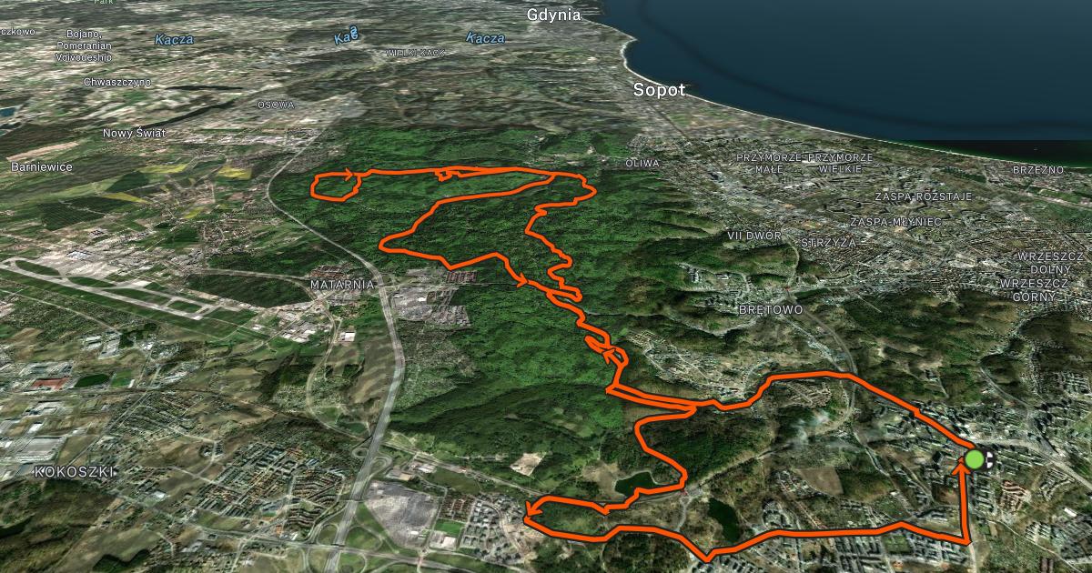
Gdańsk is famous for Baltic breezes, red-brick Gothic architecture, and the vibrant buzz of the Long Market (Długi Targ), yet deviating merely a few hundred meters away from the urban arteries lands you in an entirely different dimension. The Tricity Landscape Park is a unique post-glacial moraine playground: deep, humid ravines, whispering beech groves, steep scarps, and valleys carved out by retreating ice sheets. The afternoon wind whipping across Gdańsk Bay heralded a brisk, demanding ride. Beneath the dense forest canopy, however, ancient crowns dampened the gusts, forming a serene green refuge.
For this exploration of moraine woodlands, I chose the Trek Fuel EXe 9.7 / 9.8. This lightweight e-MTB, driven by the TQ-HPR50 motor delivering 50 Nm of torque, never imposes itself with mechanical whine—the harmonic pin-ring transmission operates in virtual silence, while the integrated 360 Wh battery provides plenty of juice for an intense, punchy loop. Weighing under 19 kilograms, it handles with the flickable agility of an analog trail bike while providing subtle wattage precisely where the moraine walls kick upward like vertical ramps. Ahead lay over 35 kilometers of varied forestry roads, doubletracks, and natural trails.
| Parameter | Data |
| Distance | 35.6 km |
| Elevation | +519 m |
| Riding Time (net) | 2h 01min |
| Bike Used | Trek Fuel EXe 9.7 / 9.8 (Lightweight E-MTB) |
| Highest Point / View | 143 m a.s.l. (km 25.7) |
| Crux Climb | 0.5 km (+71 m, max 28%) |
| Route Character | Scenic trail excursion / Forested singletracks and gravel |
Starting on the Moraine: First Meters and Forest Serenity
The loop kicked off in western Gdańsk, where residential neighborhoods yield instantly to undulating woodland ridges. Just one hundred meters in, an initial brief pause at the Orańska trailhead provided an opportunity to cinch backpack straps, verify tubeless pressures in the wide Bontrager XR5 Team Issue tires (dialed to a plush 1.5 bar), and check the discreet top-tube OLED display. The crisp air smelled of damp earth and decomposing beech leaves. Complete silence reigned, a striking contrast to the bustling metropolis just behind my back.
The opening kilometers led deeper into natural corridors. Wide doubletracks gave way to singletrack ribbons where suspension and tires soaked up exposed roots with ease. The bike rolled almost noiselessly, letting nature take center stage: creaking timber and distant birdsong. Moraine topography leaves no room for monotony—flat approaches quickly gave way to rolling terrain and undulating plateaus that set a natural pedaling cadence.
Around kilometer seven, at an elevation of 111 meters, the trail crossed the historic Wężowa Droga (Serpentine Road), a favorite path among local hikers. A four-minute pause allowed me to take in the ridge view. Tall trees cast elongated afternoon shadows over the gullies below. Wężowa Droga meanders along the hillsides, its name paying homage to the sinuous contours demanded by the rugged post-glacial relief.
Historic Forest Ways and the Moraine Wall: In the Tracks of Old Foresters
Descending off the moraine spine into the shaded valleys brought an instant microclimate shift. Cool, damp air gathered in the hollows, where emerald moss carpeted fallen logs. At kilometer 10.4, nestled at 55 meters elevation, I reached Droga Schwabego (Schwabe's Road). This atmospheric corridor with deep forestry heritage invited a ten-minute breather. Taking a sip of water under broad leafy canopies while looking up at steep ravine walls underlined just how dramatic Gdańsk's geomorphology truly is.
Shortly after, the real physical crux presented itself. Between kilometers 11.5 and 13.2, the trail kicked aggressively toward the ridge. A half-kilometer pitch gaining over 70 meters with ramps steepening to an eye-watering 28% demanded total focus and balanced weight distribution. Here, the subtle TQ motor proved its worth: 50 Nm of smooth, surge-free assist kept rear-wheel traction glued to the damp dirt without spinning out. Clearing this forest wall rewarded me with a rolling plateau and an expansive sense of open space.
The middle section delivered pure flow. The route threaded through unnamed gullies and crossed historical boundaries of pre-war forest districts. Old boundary stones and drainage ditches engineered in the early 20th century were still visible along the verges. A fast descent from kilometer 15 down toward the halfway point (dropping over 80 vertical meters within one kilometer) offered a welcome respite, while 4-piston disc brakes and Fox Performance suspension smoothed out root-strewn compressions.
The High Point at 143 m: Summit Vistas and Forest Freedom
Past the halfway mark around kilometer 18, the track began another steady ascent toward the western reaches of the moraine. The woodland composition transformed, blending grand beeches with dense pine stands and mature oaks. Near kilometer 25, the trail joined Droga Pionierów (Pioneers' Road, 105 m a.s.l.), where a seven-minute rest refreshed tired legs before the final push. Droga Pionierów preserves the rugged charm of an old transport road, quiet except for breezes rustling the canopy.
The crown of the ride arrived at kilometer 25.7, peaking at 143 meters above sea level. This is the highest elevation on the route, opening wide views over a sprawling ocean of green hills within the Tricity Landscape Park. The vibrant hub of Gdańsk sits directly below, yet from this vantage point, you see only wild, untamed nature that has resisted urban sprawl. Standing atop the crest, the raw power of the Scandinavian glacier that shaped these moraines thousands of years ago feels remarkably tangible.
A few moments of contemplation highlighted what a rare treasure these forested hills are right on the city doorstep. Pointing the front wheel downhill, dry gravel crackled beneath the tread as warm golden hour light cut through the branches, steering the way home.
Rolling Home to Close the Loop
The final nine kilometers delivered an easy descent and fast rolling stretches back toward the start. The trail wound through shaded slopes, gradually dropping in elevation. Leaving the technical sections behind, smooth forest tracks allowed easy cruising, passing suburban foresters' lodges and peaceful clearings.
An average speed of 17.6 km/h over just two hours of pure saddle time yielded a balanced, invigorating ride. Muscular fatigue paired pleasantly with the satisfaction of conquering punchy moraine climbs. Rolling back to the start point at 91 meters elevation, the battery display still showed plenty of remaining capacity—a lightweight e-MTB proved the ideal tool for this terrain without compromising genuine athletic pedaling.
Exploring Gdańsk from the trails of the Tricity Landscape Park is an exciting lesson in natural history and terrain riding. It is a route filled with rapid transitions, requiring sharp cornering skills and rewarding riders with rare forest tranquility.
Sightseeing Highlights: What to See Along the Route
- ↳ Tricity Landscape Park and Moraine Gorges: The ecological heart of the ride. This protected park preserves deep erosion ravines, post-glacial ridges, and monumental pedunculate oaks and beeches.
- ↳ Wężowa Droga (Serpentine Road): A twisting trail clinging to a ridge above 110 m a.s.l., offering deep views down into adjacent gullies on either side.
- ↳ Droga Schwabego Valley: A tranquil forest depression with a cool microclimate where lush ferns and mosses flourish, perfect for a mid-ride rest.
- ↳ Elevation Point 143 m a.s.l.: The highest summit of the loop, providing sweeping views across the forested ridges of Gdańsk.
Practical Guide: Coffee Stops, Water, and Route Tips
- ↳ Coffee Stops & Refueling: An authentic resting spot right at the start is "Orańska trailhead, Gdańsk" (km 0.1, 5-minute stop)—ideal for double-checking gear and having an initial energy bar. Later stops are purely nature-based: Wężowa Droga (km 6.7, 4 min), Droga Schwabego (km 10.4, 10 min), and Droga Pionierów (km 24.5, 7 min). Pack snacks, gels, and a thermos with coffee.
- ↳ Water Points & Shelters: There are no potable water fountains inside the forest reserve, so carry two full bidons. Wooden rain shelters and benches are located along main forest thoroughfares (Droga Schwabego, Droga Pionierów).
- ↳ Recommended Bike and Tires: A lightweight cross-country or trail mountain bike (hardtail or full suspension), or an agile light e-MTB. Tires measuring 2.35 to 2.50 inches with aggressive side knobs are vital for traversing slick roots, leaf litter, and 28% gradients.
- ↳ Navigation & GPX Track: The dense trail network can easily lead you astray into dead-end ravines. Download the GPX track to your bike computer or smartphone for seamless navigation through the Tricity Landscape Park.
Frequently Asked Questions (FAQ)
Everything you need to know before hitting this route
How long does it take to complete this route?
▾
What are the primary highlights and viewpoints along the loop?
▾
Which bike and tire setup works best on the Gdańsk moraine trails?
▾
Is this trail loop suitable for beginner cyclists?
▾
Free Bike Coloring Pages A4 for Kids & Family
65 vector coloring sheets ready to print (300 DPI, no login required). Gravel, Full MTB, E-Bike & XC!