In the Shadow of Moraine Beeches: Forest e-MTB Loop Through Tri-City Landscape Park
✨ Key Route Information (Quick Facts)
GPX Route for Garmin, Wahoo, Komoot, and Other Bike Computers
Download the free GPX track of this cycling route. The file can be used on Garmin Edge, Wahoo ELEMNT, Hammerhead Karoo, Bryton Rider bike computers and Komoot, OsmAnd, or Ride with GPS apps.
- 1. In the Shadow of Moraine Beeches: Forest e-MTB Loop Through Tri-City Landscape Park
- 2. Route at a Glance
- 3. The Moraine Gateway: Opening Miles in the Forest Canopy
- 4. Tracing Glacial History: Ravines, Erratics, and Primeval Beeches
- 5. High Moraine Ridge: 168 m a.s.l. and Expansive Vistas
- 6. Flow State Descents and Woodland Gravel Return
- 7. Scenic Highlights: What to Spot Along the Way
- 8. Practical Guide: Cafés, Water, and Field Tips
▶ Route Video & YouTube Vlog
Nakręcone Rowerem — YouTube
YouTube HD@nakrecone-rowerem • Cycling, Gravel & Mountains
Trójmiejski Park Krajobrazowy na Specialized Levo SL2 | Pętla e-MTB 42 km
Interactive GPS Map
Precise GPX track route with waypoints
Terrain & Surface Breakdown
Surface details, terrain breakdown, and gear tips
🏆 Route Highlights & Scenic Spots:
- ✓ Glacial ravines and deep moraine valleys within the forested hills of Gdańsk
- ✓ Atmospheric sections winding through centuries-old beech woods in Tri-City Landscape Park
- ✓ Technically demanding climbs with gradients ramping up to 18%
- ✓ Ridge viewpoints reaching 168 m above sea level overlooking the forested valleys
- ✓ Dynamic, winding descents over natural forest tracks and singletracks
🛣️ Terrain & Surface Breakdown
The route predominantly follows hard-packed forest tracks, natural singletracks laden with roots and stones, and gravel paths. Varied, undulating terrain with short, punchy climbs and flowy moraine descents.
🚴 Recommended Bike & Gear
A progressive trail mountain bike or a lightweight e-MTB with 140–160 mm of suspension travel is ideal. Tires with an aggressive tread measuring at least 2.3–2.4 inches set up tubeless are essential for grip on damp roots.
📍 Location — Poland
Gdańsk, Pomerania, Poland (PL) — 42.8 km, +695m.
In the Shadow of Moraine Beeches: Forest e-MTB Loop Through Tri-City Landscape Park
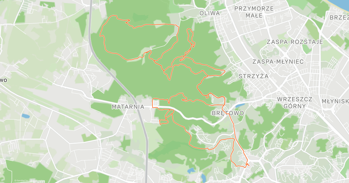
The morning air in the forested enclaves of Poland's Tri-City smells worlds apart from the seaside promenade. Simply leave the dense urban blocks behind and dive into the thick terminal moraine belt to feel the crisp, cool moisture of steaming leaf litter, ancient beech groves, and moss-draped ravine slopes. Viewed from these forest trails, Gdańsk has nothing in common with flat coastal lowlands. It is a true mountainous bastion perched right beside the Baltic bay, sculpted thousands of years ago by the retreating Scandinavian ice sheet. Our goal today is a dynamic loop just under 43 kilometers long, hidden under the lush green canopy of Tri-City Landscape Park.
| Parameter | Data |
| Distance | 42.8 km |
| Elevation | +695 m |
| Riding Time (moving) | 2h 23min |
| Bike | Specialized Turbo Levo SL 2 Comp Carbon (2025) |
| Highest Point / Vista | 168 m a.s.l. (km 8.2) |
| Crux Climb | 1.3 km (+78 m, max 18%) |
| Terrain Character | Scenic trail expedition / Forest singletrack and gravel |
The Moraine Gateway: Opening Miles in the Forest Canopy
I rolled out from an altitude of around one hundred meters above sea level, diving almost immediately into a green corridor of woodland fire roads. Urban commotion evaporated in an instant, replaced by rustling foliage and the steady hum of knobby tires rolling across damp forest loam. Morning light filtered through the thick canopy, casting geometric shafts of gold across the path. The first few kilometers served as a gentle warm-up on packed fire roads, which carved progressively deeper into the undulating folds of the terrain.
The lightweight character of the Specialized Turbo Levo SL 2 Comp Carbon suited this landscape seamlessly. The Specialized SL 1.2 motor, outputting 50 Nm of torque, hummed unobtrusively, providing natural assistance precisely when the gradient pitched violently upward. Thanks to its low overall weight of roughly 18 kilograms, the bike handled with the nimble agility of an acoustic trail rig, responding instantaneously to every shift of body weight in tight berms.
The first crux test arrived sooner than expected. Between kilometers three and six, the trail attacked a steep moraine slope: 1.3 kilometers of sustained climbing with ramps touching 18%. The Butcher and Eliminator tires dug into the damp dirt and tangled roots, while the mullet wheel setup—featuring a 29-inch front wheel and an agile 27.5-inch rear—effortlessly maintained steering precision between glacial erratic boulders.
Tracing Glacial History: Ravines, Erratics, and Primeval Beeches
The moraine landscapes of Tri-City Landscape Park hold an extraordinary geological history. The deep erosion gullies woven with singletrack were carved out by the torrents of melting Scandinavian glaciers. Ravine walls frequently slope at pitch-black angles of thirty to forty degrees, while the bottoms of these valleys shelter fast-flowing streams reminiscent of Sudeten mountain brooks. The air carries an earthy perfume of decaying timber and lush ferns, nurturing an almost primordial microclimate.
Every corner feels wonderfully raw. Every few hundred meters, moss-covered erratic boulders dragged here from Scandinavia emerge along the verge—silent testaments to glacial might. It pays to ease off the throttle here to marvel at massive monumental beeches and oaks whose roots snake across the paths like natural staircases. The route demanded unrelenting focus, yet delivered a profound sense of wilderness just a stone's throw from a bustling metropolitan area.
There was no room for distractions. I sustained an uninterrupted, steady cadence, fueling on the fly with energy bars from my jersey pocket and regular sips of electrolytes. Riding this way lets you completely merge with the woods without braking rhythm for unnecessary stops.
High Moraine Ridge: 168 m a.s.l. and Expansive Vistas
Around kilometer eight, the trail climbed onto the ride's highest ridge, topping out at 168 meters above sea level. In Baltic coastal geography, this altitude fully warrants the label of miniature mountains. On this crest, the trees thin out slightly, and gaps between the branches reveal rolling waves of green cascading down toward the Bay of Gdańsk.
I paused for barely a minute to catch my breath and tune into the silence. At this height, the wind hums through the beech crowns with a resonant, low timbre. The air felt crisp and transparent. Looking down into the steep ravines plunging toward the valley floor underscores just how geomorphologically dramatic Tri-City Landscape Park really is. Rather than a flat seaside bike path, this was thoroughbred technical cross-country and trail terrain.
The Fox suspension—a 36 Rhythm fork with 160 mm travel up front paired with a Float X Performance rear shock—stood primed. Ahead lay sections where gravity turns from adversary to accomplice, provided you keep your line choice dialed.
Flow State Descents and Woodland Gravel Return
The second half of the loop delivered that longed-for trail flow. Between kilometers 24 and 27, the track unspooled into a nearly two-kilometer descent dropping almost one hundred meters. This was pure trail riding: tight off-camber traverses, natural berms shaped by the gully walls, and root drops. The four-piston SRAM Code RS brakes clamping 200 mm rotors offered unwavering stopping power, letting me drop into corners late with zero brake fade.
The smaller 27.5-inch rear wheel of the Levo SL injected playful flickability into these tight forest switchbacks. The chassis snapped between corners intuitively, delivering precision and agile fun. Once the technical descent leveled out, the route transitioned to wide, pastoral gravel tracks where the afternoon sun cast long shadows across the trail.
The final ten kilometers formed a smooth wrap-up to the 43-kilometer loop. My legs felt every bit of the near-700-meter vertical gain, but the reward of completing this moraine circuit in a clean, flowing rhythm was immense. Tri-City Landscape Park proved once again that it can challenge and captivate any cyclist seeking authentic immersion in untamed nature.
Scenic Highlights: What to Spot Along the Way
- ↳ Glacial valleys and erosion ravines: Unique landforms where moraine slopes plunge at angles up to 40 degrees. Dense stands of beech and hornbeam foster a nature-reserve microclimate fed by rushing streams.
- ↳ Glacial erratic boulders: Scandinavian granite deposits left behind by retreating ice sheets scattered along the trails, many protected as natural geological monuments.
- ↳ Moraine ridge panoramic points: Crests approaching 170 m a.s.l. that offer sweeping views across wooded valleys and hints of the Baltic Sea during early spring or late autumn when foliage thins.
Practical Guide: Cafés, Water, and Field Tips
- ↳ Coffee Stop & Local Bites: I rode the full 42.8 km non-stop, relying purely on pocket nutrition, bars, and electrolytes. If you crave a post-ride espresso stop, drop down into Gdańsk's Oliwa or Wrzeszcz districts, where specialty coffee shops serve third-wave roasts and artisan bakeries deliver top-tier fuel.
- ↳ Water sources and shelters: There are no potable drinking fountains deep inside the forest of Tri-City Landscape Park. Carry two full bidons (at least 1.5 liters of fluid). Several covered wooden forestry shelters line the trails if you need emergency protection from coastal rain.
- ↳ Recommended bike and tires: Given the punchy gradients, exposed roots, and rocks, an all-mountain/trail mountain bike or lightweight e-MTB with 130–150 mm travel is ideal. Tires sized 2.3–2.4 inches with aggressive side knobs running at 1.4–1.6 bar provide reliable traction on wet leaf litter.
- ↳ Navigation & GPX: The dense network of logging roads and trails can easily disorient. Loading the GPX track onto your cycling computer or phone is crucial to staying on track.
Frequently Asked Questions (FAQ)
Everything you need to know before hitting this route
How long does it take to ride this loop in Tri-City Landscape Park?
▾
What are the main landscape features and points of interest on the trail?
▾
What type of bike and tires are best suited for this route?
▾
Free Bike Coloring Pages A4 for Kids & Family
65 vector coloring sheets ready to print (300 DPI, no login required). Gravel, Full MTB, E-Bike & XC!