Gravel Loop from Gdańsk to Malbork: Through the Endless Vistula Fens to the Teutonic Fortress
✨ Key Route Information (Quick Facts)
GPX Route for Garmin, Wahoo, Komoot, and Other Bike Computers
Download the free GPX track of this cycling route. The file can be used on Garmin Edge, Wahoo ELEMNT, Hammerhead Karoo, Bryton Rider bike computers and Komoot, OsmAnd, or Ride with GPS apps.
- 1. Gravel Loop from Gdańsk to Malbork: Through the Endless Vistula Fens to the Teutonic Fortress
- 2. Route at a Glance
- 3. Toward the Plains: Descending the Moraine into the Żuławy Expanse
- 4. Gothic Brick and the Waters of the Nogat: Turnaround at Malbork Castle
- 5. Pastoral Return: Canals, Dikes, and the Approach to Pruszcz Gdański
- 6. Crux Climb up the Moraine: Summit at 126 m a.s.l.
- 7. Sightseeing Highlights along the Route
- 8. Practical Guide: Nutrition, Water, and Ride Advice
Interactive GPS Map
Precise GPX track route with waypoints
Terrain & Surface Breakdown
Surface details, terrain breakdown, and gear tips
🏆 Route Highlights & Scenic Spots:
- ✓ Fast descent from the Gdańsk moraine hills onto the low-lying plains of the Vistula Fens
- ✓ Charming polder villages featuring historic Mennonite-influenced timber architecture around Cedry Wielkie
- ✓ Monumental panorama of the Teutonic Castle in Malbork seen across the Nogat River
- ✓ Smooth gravel segments running along drainage canals and historic railway tracks
- ✓ Demanding final climb back up the moraine ridge with panoramic views over the Tricity area
🛣️ Terrain & Surface Breakdown
Dominated by smooth gravel roads, compacted dirt agricultural paths, and quiet secondary asphalt backroads with minimal traffic. Over 95 kilometers are virtually dead flat across the reclaimed polders, framed by an opening downhill spin and a decisive moraine climb on the return into Gdańsk.
🚴 Recommended Bike & Gear
An all-road gravel rig or lightweight cross bike with 38 mm to 45 mm tires is ideal, balancing low rolling resistance on hardpack with reassuring damping on rougher farm connectors. Given the wide-open polder plains, prepare for persistent head- or crosswinds and carry two full bidons alongside energy snacks in your jersey pockets.
📍 Location — Poland
Gdańsk, Pomerania, Poland (PL) — 133.6 km, +312m.
Gravel Loop from Gdańsk to Malbork: Through the Endless Vistula Fens to the Teutonic Fortress
The early morning air in Gdańsk carries the brisk bite of the Baltic sea breeze mingled with the damp aroma of coastal beech forests clinging to the moraine slopes. Rolling out at dawn from over a hundred meters above sea level delivers an instant burst of adrenaline on the swift descent toward the delta plains. Leaving the awakening city in my wake, the route opens up a ride that links two contrasting worlds in a single day: the dynamic ridges of the Tricity region and the pancake-flat, hypnotic expanses of the Vistula Fens (Żuławy Wiślane). The turnaround goal is Malbork—the legendary red-brick Gothic stronghold—reached via ribbons of fast gravel, canal dikes, and whisper-quiet service roads.
The gravel bike hums along the opening sectors, effortlessly racking up distance. Taking on 133 kilometers demands calculated pacing, especially because out in the open polders the wind can turn into a punishing rival without tree cover to break its force. Today, however, the forecast is calm, and the rising sun begins burning through the low morning mist hugging the dense network of drainage channels.
Route at a Glance
| Metric | Data |
| Distance | 133.6 km |
| Elevation | +312 m |
| Moving Time | ~5h 47m |
| Bike Setup | Gravel Bike (Gdańsk - Malbork Loop) |
| High Point / Viewpoint | 126 m a.s.l. (km 126) |
| Key Climb | 3.1 km (+92 m, max 7%) |
| Route Character | Endurance gravel ride / Fast gravel flow and quiet backroads |
Toward the Plains: Descending the Moraine into the Żuławy Expanse
The initial kilometers are all about downhill speed. The drop from the Gdańsk moraine toward the Vistula delta spans nearly three kilometers of sweeping flow, where the cold rush of air shakes off any remaining sleepiness. The bike tracks securely through long curves as tarmac yields to farm lanes. Crossing into the Cedry Wielkie area, the landscape transforms instantly: the wooded slopes vanish behind, and the horizon stretches out for miles beneath an expansive sky.
The Vistula Fens greet riders with the rich scent of moist silt and the rustle of tall reed beds flanking drainage ditches. Under the tires, the gravel is bone-dry, hard-packed, and blisteringly fast. Solitary rows of pollarded willows stand like sentinels across the polders, echoing the land-reclamation legacy of Dutch Mennonite settlers who tamed this delta centuries ago. Traffic is practically nonexistent; the only sounds are the steady buzz of rolling tires and larks singing high above the fields.
Pedaling here is meditative. Every pedal stroke reels in the historical heartland of the Teutonic Order. Around kilometer 28, the route plunges deep into the fens, where elevation dips to just a few meters above sea level. The geometric order of ditches, dikes, and vast agricultural parcels creates a soothing, measured cadence.
Gothic Brick and the Waters of the Nogat: Turnaround at Malbork Castle
As the odometer ticks past 50 kilometers, the route weaves toward the banks of the Nogat River, where deep history overtakes the agricultural scenery. The scent of sun-warmed wild grasses and riverbank brush fills the air. Crossing maintenance bridges and quiet dikes reveals sluggish river currents that once served as fortified moats.
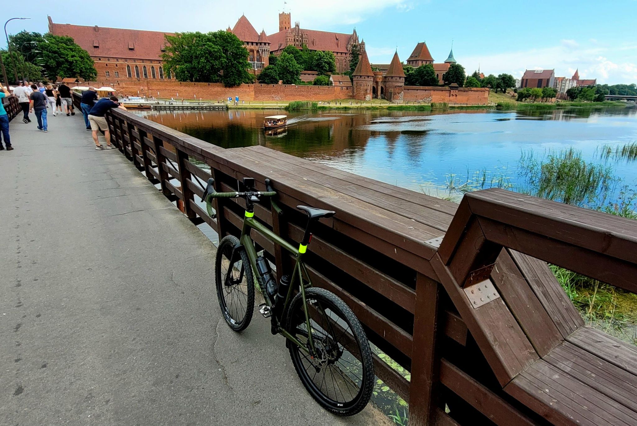
The visual crescendo arrives at kilometer 69. Breaking through a stand of venerable trees, the soaring red-brick ramparts of Malbork Castle suddenly command the riverbank. Confronting the largest brick castle complex on the planet from water level demands an instinctive tap on the brakes. The saturated red masonry offers a striking contrast to the lush meadows and rippling river below. From the saddle, the fortress feels even more imposing than from inside the tourist-choked courtyards.
With a brisk pace to maintain, there is no lingering in gift shops. A short breather along the riverside path, an energy gel pocketed down, a few gulps of electrolyte mix from the bidon, and the tires are rolling north again. The historic chill of medieval stone lingers as the return trek gets underway.
Pastoral Return: Canals, Dikes, and the Approach to Pruszcz Gdański
The return leg traces the western perimeter of the delta along remote access roads and flood-defense embankments. Here, the gravel surface turns a touch coarser with embedded stones, but wide tubeless tires soak up the chatter without losing momentum. The cultural scenery shines with traditional arcade houses (domy podcieniowe) half-hidden behind lime tree alleys—historic monuments to prosperous delta farming estates.
By kilometer 100 near Pruszcz Gdański, the flatlands begin their gradual exit. Legs are carrying fatigue, yet a steady cadence and steady carbohydrate fueling keep the average rolling speed above 23 km/h. Pruszcz marks the meeting point with the historic Radunia Canal, a medieval marvel of hydro-engineering leading back toward Gdańsk.
The late afternoon light softens, casting long shadows across the gravel strip. This is where satisfaction blends with anticipation for the day's final sting: the climb back onto the moraine.
Crux Climb up the Moraine: Summit at 126 m a.s.l.
After more than 120 kilometers of uninterrupted flat spinning, the topography shifts abruptly. The crucial climb begins: over three kilometers of continuous ascent ramping up to a 7% gradient. Leaving the polders behind, the track cuts upward into wooded ravines and the rolling outskirts of Gdańsk. Pedaling out of the saddle becomes essential as breathing quickens to match the climbing grade.
At kilometer 126, the route hits its zenith at 126 meters above sea level. From the open crest of the moraine, a magnificent vista unfolds: looking back across the hazy, flat sea of the Vistula Fens crossed hours earlier, with the waters of Gdańsk Bay shimmering on the far horizon. The cool breeze on the ridge is the ultimate reward for nearly six hours of sustained effort.
The closing kilometers are a gentle roll down to the starting point in Gdańsk. The 133-kilometer loop wraps up with unforgettable memories of peaceful fens, medieval grandeur, and Baltic coastal hills.
Sightseeing Highlights along the Route
- ↳ Malbork Castle and Nogat River Boulevard: The monumental headquarters of the Teutonic Knights and the world's largest brick fortress. The cycle path hugging the Nogat banks offers the best unobstructed view of the High and Middle Castles. Slow down along the riverside trail to appreciate the scale of medieval engineering.
- ↳ Arcaded Houses and Mennonite Heritage: Around Cedry Wielkie and neighboring hamlets, spot timber-framed arcaded houses with decorative overhanging upper stories supported by wooden pillars—built by 16th- and 17th-century Dutch settlers who drained these floodplains.
- ↳ Gdańsk Moraine Ridge Viewpoint (126 m a.s.l.): The glacial hills southwest of Gdańsk act as a natural terrace, showcasing the sharp transition between the glacial uplands and the low-lying Vistula delta.
Practical Guide: Nutrition, Water, and Ride Advice
- ↳ Nutrition & Post-Ride Recovery: This 133 km loop was completed in a continuous endurance style without extended cafe stops. Pack at least 4–5 energy bars, gels, and electrolyte mix. Back in Gdańsk, reward yourself with an espresso and hearty meal in the historic city center or Wrzeszcz district.
- ↳ Water Stops and Rest Shelters: Water can be replenished at local village shops in Cedry Wielkie, Miłoradz, or near Malbork. Covered trail pavilions with tables line the Nogat dikes and marked regional cycle paths, providing sheltered spots for quick maintenance checks.
- ↳ Recommended Bike and Tires: A gravel bike running 38–42 mm semi-slick tires provides the perfect sweet spot. The paths are largely smooth, and high-volume tires comfortably cushion rare concrete slabs or washboard gravel without sacrificing tarmac rolling speed.
- ↳ Navigation and GPX Route: Finding your way through the maze of irrigation ditches and farm lanes can prove tricky due to few distinct landmarks. Upload the GPX track to your bike computer to avoid dead-end tractor paths that abruptly terminate at drainage dikes.
Frequently Asked Questions (FAQ)
Everything you need to know before hitting this route
How long does it take to complete this gravel route?
▾
What are the top landmarks and viewpoints to see along the way?
▾
What type of bike and tires are best for the Gdańsk - Malbork loop?
▾
Free Bike Coloring Pages A4 for Kids & Family
65 vector coloring sheets ready to print (300 DPI, no login required). Gravel, Full MTB, E-Bike & XC!