Gravel Loop from Gdańsk to the Moraine Hills of the Kashubian Lake District: 108 km Across Forests, Lakes, and Secluded Gravel
✨ Key Route Information (Quick Facts)
GPX Route for Garmin, Wahoo, Komoot, and Other Bike Computers
Download the free GPX track of this cycling route. The file can be used on Garmin Edge, Wahoo ELEMNT, Hammerhead Karoo, Bryton Rider bike computers and Komoot, OsmAnd, or Ride with GPS apps.
- 1. Gravel Loop from Gdańsk to the Moraine Hills of the Kashubian Lake District: 108 km Across Forests, Lakes, and Secluded Gravel
- 2. Route & Bike Spec Sheet
- 3. Toward the Moraines: Early Morning Departure from Gdańsk
- 4. Heart of the Kashubian Lake District: Forests, Pine Woods, and Quiet Hamlets
- 5. The Crux: The Wall at Przywidz and Moraine Panorama at 273 m a.s.l.
- 6. Descents Toward the Coast: Afternoon Sun and the Return to Gdańsk
- 7. Sightseeing Highlights: What to See Along the Route
- 8. Practical Field Guide: Cafés, Water, and Logistics
▶ Route Video & YouTube Vlog
Nakręcone Rowerem — YouTube
YouTube HD@nakrecone-rowerem • Cycling, Gravel & Mountains
Kaszuby na Gravelu: Najlepsze szutry w okolicy Trójmiasta!
Interactive GPS Map
Precise GPX track route with waypoints
Terrain & Surface Breakdown
Surface details, terrain breakdown, and gear tips
🏆 Route Highlights & Scenic Spots:
- ✓ Scenic moraine ridge near Przywidz (273 m a.s.l.) with sweeping panoramic views of rolling fields and woodlands
- ✓ Fast forest gravel trails and picturesque riverside sectors along the Radunia River near Kolbudy
- ✓ Secluded gravel backroads traversing peaceful villages and woodlands around Nowa Karczma and Lubieszynek
- ✓ Varied post-glacial terrain with dynamic descents and steep ramps pitching up to 22%
🛣️ Terrain & Surface Breakdown
The route blends fast forest gravel, hard-packed dirt tracks, and quiet rural tarmac lanes with virtually no motorized traffic. The terrain is distinctly rolling: the Kashubian moraine hills rack up over 1000 metres of elevation gain, including punchy climbs ramping up to 22% alongside fast, sweeping gravel descents.
🚴 Recommended Bike & Gear
A modern gravel bike or a lightweight cross/MTB hardtail is ideal. We recommend tires between 40 mm and 45 mm with an all-round tread pattern (such as Pirelli Cinturato Gravel M) to guarantee confident grip on loose gravel, pine needles, and sand patches. Given the 108 km distance and frequent climbing, carry two full water bottles and a tubeless repair kit.
📍 Location — Poland
Gdańsk, Pomerania, Poland (PL) — 108.8 km, +1040m.
Gravel Loop from Gdańsk to the Moraine Hills of the Kashubian Lake District: 108 km Across Forests, Lakes, and Secluded Gravel
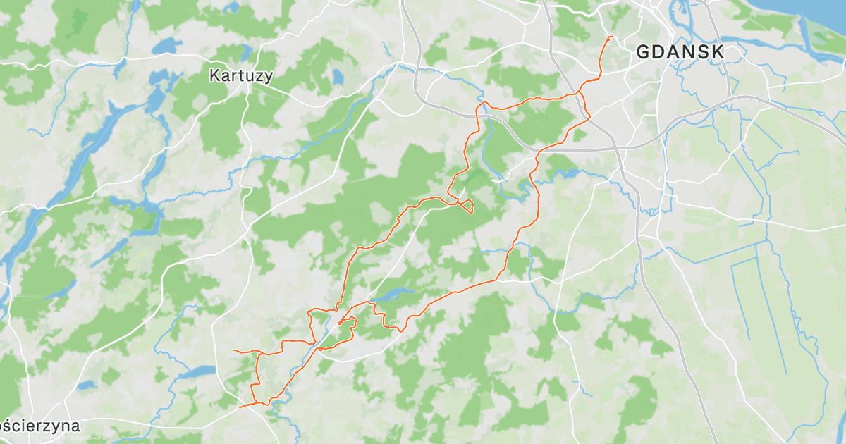
The morning air in Gdańsk brings a brisk chill that sharpens the senses immediately. As the city slowly stirs to life, my bike rolls southwest toward the rolling horizon of the Kashubian Lake District. Today's plan is both simple and ambitious: escape the urban hustle, dive deep into secluded forests, and savor genuine Pomeranian gravel under tire. Ahead lies a loop of more than one hundred kilometers across moraine hills, carved river ravines, and quiet Kashubian hamlets where time flows at its own leisurely pace.
This post-glacial moraine topography consistently surprises newcomers. Despite the close proximity of the Baltic Sea on the map, the terrain shares nothing with lowland monotony. Every kilometer heading west from the Tri-City area is a gradual ascent onto post-glacial ridges carved by ravines, tunnel valley lakes, and dense mixed forests. You immediately sense open space, the damp scent of the forest floor, and warm pine needles—hallmarks of an epic day in the saddle.
| Parameter | Value |
| Distance | 108.8 km |
| Elevation | +1040 m |
| Moving Time | ~5h 35m |
| Bicycle Used | Rose Backroad AL GRX 400 (2020) |
| Highest Point / Panorama | 273 m a.s.l. (km 80.5) |
| Crux Climb | 0.7 km (+52 m, max 22%) |
| Route Character | Physically demanding endurance ride / Fast gravel flow and quiet rural lanes |
Toward the Moraines: Early Morning Departure from Gdańsk
I spin an easy cadence through the morning chill, leaving the main thoroughfares of Gdańsk behind. The early hour keeps car traffic virtually non-existent, and the coastal breeze from Gdańsk Bay soon gives way to sheltered suburban lanes. With every passing kilometer toward Łapino Kartuskie and Kolbudy, urban sprawl dissolves into broad swathes of green. Soon I reach the valley of the Radunia River—a brisk waterway flowing with almost alpine vigor that carved deep gorges into this earth centuries ago.
Tarmac naturally fades into gravel. My Rose Backroad AL GRX 400 settles into its natural element. The aluminum frame damps minor road chatter while the carbon fork delivers pinpoint steering through tight forest bends. The 45 mm Pirelli Cinturato Gravel M tires, inflated to just over 2 bar, hum smoothly on hard-packed soil, providing unwavering cornering grip across damper sections of the trail.
Past Łapino and Czapielsk, the landscape adopts a wilder rural-forest character. The terrain begins to roll—short drops into damp hollows followed by snappy kickers under tree-lined farm avenues. Morning sunlight filters through majestic oaks and beeches, casting stripes across the dirt. The scent of cut grass and pine resin fills the crisp air. It is that magical moment where city thoughts completely vanish, replaced by the rhythmic cadence of deep breathing.
Heart of the Kashubian Lake District: Forests, Pine Woods, and Quiet Hamlets
The middle section of the loop traverses the borderlands of Kolbudy, Nowa Karczma, and Liniewo. The surroundings of Czarna Huta and Jasiowa Huta capture the essence of rural Kashubia: standalone red-brick farmhouses, weathered wooden barns, and wayside crosses gracing unpaved junctions. Car traffic is practically absent. Instead, quiet sandy-gravel doubletracks snake along forest edges and young pine stands.
The surface changes regularly. Smooth hardpack occasionally turns into loose sandy patches left by recent rains, but the wide tires with pronounced shoulder knobs handle it effortlessly without wheel slip. Around kilometer 55, the route rolls through Nowa Karczma and Lubieszynek. The horizon opens wide across expansive rolling meadows, unveiling distant blue moraine ridges.
Riding this terrain demands respect for glacial geology. There are virtually no flat stretches; the route rolls continuously, demanding frequent shifts in body weight and micro-adjustments in cadence. I pull over briefly in a sunny woodland clearing past Lubieszynek to savor absolute quiet, listening only to the wind through pine branches and the pinging of cooling brake rotors.
The Crux: The Wall at Przywidz and Moraine Panorama at 273 m a.s.l.
The most demanding and scenic stretch of the loop unfolds right past Lake Przywidzkie. Here the route hits its ultimate climbing test. Between kilometer 74 and 75 sits a grueling 700-meter wall. The average gradient is stout, with ramps pitching up to a ruthless 22%. The Shimano GRX RX400 groupset with compact gearing provides the right cogs to keep the cranks turning, but every meter requires pure focus, weighting the rear tire over loose gravel, and laying down sustained wattage out of the saddle.
The physical toll pays off near kilometer 80, where the route summits at 273 m above sea level—the day's highest point. A sweeping 360-degree panorama of the Kashubian Lake District opens up: a patchwork of green fields, dark pine forests, and shimmering lakes cradled in valley floors. The breeze is cooler up here, highlighting the cumulative vertical gain. Standing here, you realize how raw and diverse Pomerania can be just a short pedal from the Baltic coast.
After a well-earned pause on the crest comes the reward: a rapid 3-kilometer gravel descent plunging back toward the valley floor. The bike tracks steadily, hydraulic disc brakes modulate effortlessly ahead of tight forest switchbacks, and the high-volume rubber absorbs loose stones. The speed quickly tops 50 km/h, wind roaring past the helmet with pure gravel flow euphoria.
Descents Toward the Coast: Afternoon Sun and the Return to Gdańsk
The final quarter of the ride is a steady, net-downhill journey back toward the Gdańsk metropolitan area. Rolling from Przywidz and Piekło Dolne eastward through Borowina and Jankowo Gdańskie, the late-afternoon sun casts elongated shadows across golden agricultural fields.
The elevation profile eases, with gravity working in your favor. Sustained downhill gradients outnumber climbs, allowing you to sustain a quick pace without burning excessive matches. Low-traffic paved lanes alternate with fast hardpack tracks. Legs definitely feel the 100+ kilometers and over 1,000 meters of vertical gain, but it is the deeply satisfying fatigue of an authentic gravel tour.
As the skyline of Gdańsk reappears on the horizon, the computer clocks nearly 109 kilometers. This ride is the purest essence of modern gravel: zero rush, total immersion in nature, and an intimate exploration of a region that continuously reveals fresh wonders from the saddle.
Sightseeing Highlights: What to See Along the Route
- ↳ Lake Przywidzkie and Historic Park in Przywidz: A picturesque glacial tunnel valley lake surrounded by beech forests. Przywidz features a historic village layout and a neo-Gothic church. The lakeside trail offers a pleasant setting for a brief rest and nutrition stop before tackling the crux climb.
- ↳ Radunia River Gorge near Kolbudy: One of Pomerania's most impressive geological formations. The river cuts deeply through moraine hills, creating a valley reminiscent of sub-mountainous terrain. Crossings over wooden bridges offer great vantage points over the rapid current and historic hydro plants that have harnessed water power for over a century.
- ↳ Traditional Vernacular Architecture in Nowa Karczma: Small settlements along the way preserve regional architecture, from turn-of-the-century red-brick houses to intricate wrought-iron roadside shrines reflecting local cultural heritage.
Practical Field Guide: Cafés, Water, and Logistics
- ↳ Coffee Stops & Resupply: For a sustained mid-ride break, Gdańska, Lubieszynek (km 56.6, 14-minute stop) offers a great opportunity to recharge calories at the halfway mark. At the start and finish, Franciszka Rakoczego, Gdańsk (km 0) is an ideal staging area for pre-ride espresso or post-ride replenishment. Shorter technical pauses can be made at Jabłoniowa, Łapino Kartuskie (16.9 km), 221, Czapielsk (20.9 km), Reknicka, Marszewo (28.1 km), Biała, Czarna Huta (40.7 km), Jesionowa, Jasiowa Huta (49.5 km), Kamiony, Nowa Karczma (54 km), Horniki Górne, Lubieszynek (55.9 km), 221, Lubieszynek (57.1 km), Łąkowa, Borowina (65.5 km), Taneczna, Piekło Dolne (71.6 km), Szkolna, Przywidz (74.5 km), and Generała Józefa Wybickiego, Jankowo Gdańskie (100.2 km).
- ↳ Water Points & Shelters: Local grocery stores in Nowa Karczma, Przywidz, and Kolbudy are reliable for refills. Sheltered resting pavilions can be found near the municipal beach in Przywidz and within Kolbudy forestry parking lots.
- ↳ Bike & Tire Setup: A gravel bike or lightweight hardtail MTB fitted with 40–45 mm tires. Given sandy pitches on woodland climbs and loose rocks on descents, a tubeless setup run between 2.0 and 2.3 bar delivers optimal compliance and grip.
- ↳ Navigation & GPX: The track occasionally weaves through unmarked forest aisles. Loading the GPX file onto a GPS head unit or smartphone navigation app is strongly advised to avoid wrong turns.
Frequently Asked Questions (FAQ)
Everything you need to know before hitting this route
How long does it take to complete this 108 km route?
▾
What are the top scenic highlights along the route?
▾
What type of bike and tires are recommended?
▾
Is this gravel route suitable for beginners?
▾
Free Bike Coloring Pages A4 for Kids & Family
65 vector coloring sheets ready to print (300 DPI, no login required). Gravel, Full MTB, E-Bike & XC!