Kashubian Switzerland from a Gravel Perspective: Gravel Loop around Stężyca and Raduńskie Lakes
✨ Key Route Information (Quick Facts)
GPX Route for Garmin, Wahoo, Komoot, and Other Bike Computers
Download the free GPX track of this cycling route. The file can be used on Garmin Edge, Wahoo ELEMNT, Hammerhead Karoo, Bryton Rider bike computers and Komoot, OsmAnd, or Ride with GPS apps.
- 1. Kashubian Switzerland from a Gravel Perspective: Gravel Loop around Stężyca and Raduńskie Lakes
- 2. Route at a Glance
- 3. Toward the Trail: Morning Serenity in Moraine Valleys
- 4. Centuries of Lore: Węsiory, Przewóz, and Kashubian Solitude
- 5. The Crux: The Wall at Nowe Czaple and Panorama at 241 m a.s.l.
- 6. Pastoral Finish: The Descent to Stężyca
- 7. Sightseeing Highlights along the Route
- 8. Practical Guide: Coffee, Water, and Gear Notes
▶ Route Video & YouTube Vlog
Nakręcone Rowerem — YouTube
YouTube HD@nakrecone-rowerem • Cycling, Gravel & Mountains
Przetestowałem Rose Backroad AL na Kaszubach! [GoPro 11]
Interactive GPS Map
Precise GPX track route with waypoints
Terrain & Surface Breakdown
Surface details, terrain breakdown, and gear tips
🏆 Route Highlights & Scenic Spots:
- ✓ Picturesque vistas over Upper Raduńskie Lake and Lake Długie
- ✓ Proximity to the historic Goth stone circles in Węsiory and the Radunia river valley
- ✓ Moraine summit at 241 m a.s.l. offering sweeping panoramic horizons
- ✓ Fast, flowy gravel ribbons winding through beech and pine forests of the Kashubian Landscape Park
🛣️ Terrain & Surface Breakdown
The loop balances smooth, hard-packed forest and field gravel tracks with low-traffic, well-paved local asphalt roads. Includes brief sections of concrete 'jumbo' slabs and natural woodland trails. Typical moraine topography: punchy, short kickers followed by flowing, winding descents.
🚴 Recommended Bike & Gear
A gravel bike fitted with 40-45 mm tires offers the sweet spot between high rolling speed on asphalt connectors and planted confidence over loose gravel and sandy pine needles. Running 2.0-2.3 bar in a tubeless setup provides plush vibration damping.
📍 Location — Poland
Municipality of Stężyca, Pomerania, Poland (PL) — 45.8 km, +427m.
Kashubian Switzerland from a Gravel Perspective: Gravel Loop around Stężyca and Raduńskie Lakes
The morning air over Upper Raduńskie Lake carries the scent of damp calamus and the crisp breeze of deep pine woods. As dawn light slices through the mist rolling off the post-glacial gullies, Stężyca stirs quietly awake. Starting from the heart of the Kashubian Landscape Park, this gravel loop delivers an experience that sticks in a cyclist's memory for years. Rather than high alpine cols, the glacial moraine landscape of Kashubian Switzerland dishes out a relentless, mesmerizing rhythm of morning light, glistening waters, and fragrant woodland tracks. There is no need to rush—this ride is an ode to wide open landscapes, pine scents, and living heritage nestled inside untouched nature.
| Parameter | Details |
| Distance | 45.8 km |
| Elevation | +427 m |
| Moving Time | ~2h 26m |
| Bike Tested | Rose Backroad AL GRX 400 (2020) |
| High Point / Vista | 241 m a.s.l. (km 41.8) |
| Crux Climb | 0.4 km (+58m, max 28%) |
| Route Character | Scenic gravel touring / Flowing gravel and quiet backroads |
Toward the Trail: Morning Serenity in Moraine Valleys
The first pedal strokes begin in Stężyca, tracing quiet village lanes. Within hundreds of meters, houses give way to expansive fields fringed by deep woods. My Rose Backroad AL GRX 400 rolls effortlessly over narrow asphalt before turning directly onto the first sector of pristine, hard-packed gravel. The Pirelli Cinturato Gravel M 700x45c tires bite into the damp ground with a muted hum, delivering instant stability.
At kilometer 6, I pull over for a quick pause on Jana III Sobieskiego street in Stężyca. A three-minute stop is plenty to take in the sapphire gleam of the lake below and zip up the wind vest. The morning is crisp, and the air across the Kashubian Lake District has a refreshing, pristine clarity.
The route unfurls in sweeping arcs deeper into the forest. As the morning sun rises higher, tall pines cast geometric shadows across pale gravel. The surface here is smooth as a tabletop, tailor-made for maintaining a rhythmic, steady cadence without scrubbing momentum.
Centuries of Lore: Węsiory, Przewóz, and Kashubian Solitude
The route bends southwest toward Węsiory, an area steeped in archaic folklore and the traces of ancient Goths who erected mysterious megalithic stone circles and barrows here centuries ago. Sweeping along the shore of Lake Długie, I ease off the wattage. At kilometer 14, I mark a short break near '7 / chram' on Jeziorna street. A quick three-minute breather on the fringe of the reserve reveals the unique microclimate: damp moss, bark resin, and a cool draft coming off the water.
From here, the track carves northeast along backcountry lanes toward Przewóz. The path passes traditional Kashubian farmsteads, intricate roadside wooden crosses, and hidden forest ponds mirroring an open blue sky. The Kashubian terrain grants no idle coasting: flat stretches yield to punchy, rolling moraine kickers that keep legs engaged.
Around kilometer 33, I reach Przewóz, taking a breather along regional road 228. This 13-minute rest marks the longest break of the ride—time to hydrate, grab a quick bite, and absorb the serene rural tempo of a village cradled by moraine ridges and the winding Radunia river.
The Crux: The Wall at Nowe Czaple and Panorama at 241 m a.s.l.
Leaving Przewóz behind, the terrain turns notably wilder and more corrugated. At kilometer 37, I take a moment at the rest area in Nowe Czaple. It is a smart staging point to regroup before tackling the steepest gradient of the loop.
Between kilometers 39 and 40, the forest track turns into a pure trial of legs and grip: over just 400 meters, you punch out 58 meters of vertical climbing, with ramps pitching to a stinging 28%. The 45c volume grips the loose dirt and exposed roots tenaciously, avoiding rear wheel spinouts. The payoff is immediate: breaking out of the tree canopy, you crest the top of the route at 241 m a.s.l. (km 41.8).
The view unfolding here is the true essence of Kashubian Switzerland. Rolling green crowns of moraine ridges stretch out, separated by the deep troughs of the Raduńskie Lakes. The wind whispers softly across the brow, while far below, white sails drift silently across Upper Raduńskie Lake.
Pastoral Finish: The Descent to Stężyca
After the rush of the crux climb, the terrain yields a rewarding, sweeping gravel descent hugging the forest edge. Speed builds cleanly while plush tires soak up tractor ruts and washed-out gravel chatter.
The closing kilometers deliver an easy roll back to Stężyca. Warm afternoon sun slants across wooden fences, accompanied by the fragrance of cut hay and pine resin. The loop closes at 45.8 km. Your legs hold the pleasant fatigue of moraine elevation gain, while your mind rests completely reset by the quiet majesty of Kashubia.
Sightseeing Highlights along the Route
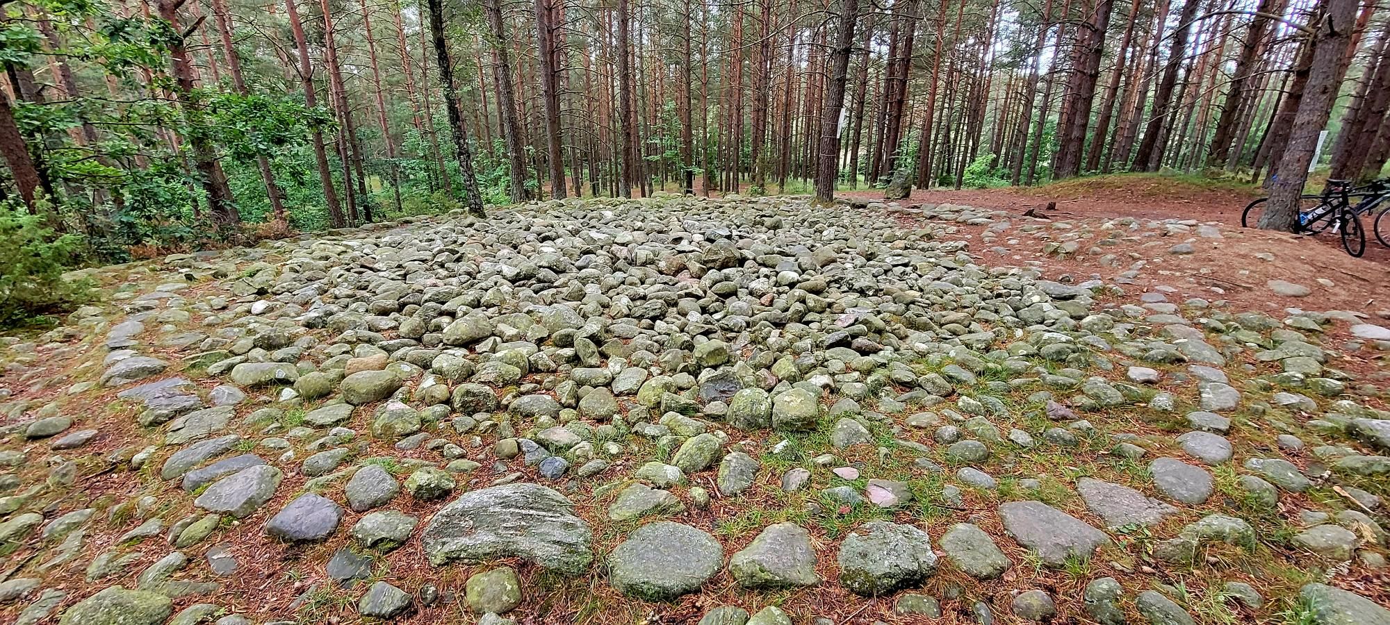
- ↳ Stone Circles in Węsiory (near km 14): Situated just north of the route, this 1st–3rd century CE Gothic and Gepid burial site features burial mounds and stone rings nestled under century-old pines by Lake Długie. Well worth stepping off the pedals for a quiet walk.
- ↳ Upper and Lower Raduńskie Lakes: The beating heart of the 'Raduńskie Circle' lake chain linked by the Radunia river. Multiple viewpoints showcase deep post-glacial waters, and Stężyca features an inviting waterfront promenade.
- ↳ Moraine Viewpoint near Nowe Czaple (km 41.8): A prominent ridge west of Wieżyca. Clear days offer visibility stretching kilometers across the glacial topography of the Kashubian Landscape Park.
Practical Guide: Coffee, Water, and Gear Notes
- ↳ Coffee Stops & Local Flavor:
- ↳ - Jana III Sobieskiego (km 6.1, Stężyca): Great option for a scenic lakeside espresso right after rolling out or upon returning.
- ↳ - 7 / chram (km 14.0, Węsiory): A quiet forest-edge stop close to the stone circle reserve.
- ↳ - 228 Roadside (km 33.3, Przewóz): Peaceful rest stop in the village center, perfect before the final wall.
- ↳ Water & Rest Areas: A sheltered tourist gazebo stands at km 37.1 in Nowe Czaple. Grocery shops to top up water and snacks are located in Stężyca, Węsiory, and Przewóz.
- ↳ Bike & Tires: Gravel or lightweight cross-country bikes with 40-47 mm tires are optimal. Firm gravel, scattered sand pockets, and steep pinches benefit from a mixed-terrain tread pattern and dialed-in low tire pressures.
- ↳ Navigation: Deep gullies and branching forestry roads can complicate navigation; load the GPX track to your bike computer beforehand as cellular service can fade in valley depressions.
Frequently Asked Questions (FAQ)
Everything you need to know before hitting this route
How long does it take to complete this gravel loop?
▾
What are the main sights and viewpoints on the route?
▾
What bike and tire setup works best for this loop?
▾
Free Bike Coloring Pages A4 for Kids & Family
65 vector coloring sheets ready to print (300 DPI, no login required). Gravel, Full MTB, E-Bike & XC!